 The Conserve Wildlife Foundation of New Jersey (CWFNJ) is proud to release its first interactive GIS-based story map, “American Oystercatchers Through the Seasons“, which brings to life the role New Jersey plays in the breeding, migratory, and wintering cycles of this charismatic coastal species.
A Story Map is a web-based interactive GIS map embedded with multimedia content, such as text, photographs, and video. CWFNJ, working with GIS software developer ESRI and with financial assistance provided by a grant from the New Jersey Division of Fish & Wildlife, plans to make this Story Map the first of many, helping engage the public about New Jersey’s rare wildlife in a dynamic and interactive way.
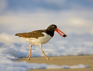
“American Oystercatchers Through the Seasons” tells the story about a species of migratory bird, the American Oystercatcher, which spends the summer breeding season along the New Jersey coast, but is present year-round along the southern New Jersey coast. Our state represents the northern limit of the species’ winter range. While some New Jersey birds migrate during the winter to Florida, those that breed in New England during the summer may end up spending their winter here in New Jersey.
This Story Map also provides stories about individual banded birds, which have been tracked on journeys between New Jersey and southern states such as Florida, as well as between New Jersey and more northern states, such as Massachusetts.